HOW MineMatch HANDLES MINERALISATION, ALTERATION,
WEATHERING,
DEPOSIT ZONES AND ROCKS – HOST OR COUNTRY IntroductionA fundamental requirement of any computer system that sets out to recognise and measure similarities is that the same language be used for all descriptions that are to be compared. MineMatch provides such a standardized language for the description of mineral deposits and deposit models which emphasises the observable characteristics of deposits, while at the same time allowing the input of certain interpreted information (such as a deposit’s setting). Interestingly, it is not sufficient, when standardizing such a language, to simply compile a rich vocabulary which might be acceptable to most geologists - the nature of the relationships between words from the vocabulary also have to be characterized, and decisions taken as to which words may qualify which other words. The rules governing which words may be used in a language, and how they may inter-relate, are commonly referred to as an “Ontology”, and it is very useful for the user of a language to be aware of its ontology. This document provides a brief introduction to crucial parts of the MineMatch ontology. The parts not discussed are self-evident when the system is used to describe a deposit, since the system automatically provides the user with descriptive vocabulary that depends on the aspect of the deposit being described. This document aims to make the description of deposits and models, in a language amenable to machine-comparison, an easier and more interesting exercise than simple data capture. A Typical Zoned Orebody
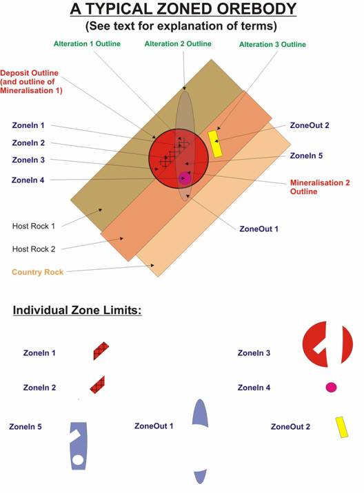
Figure 1 illustrates a typical zoned orebody, and introduces the following concepts, which are fundamental to mineral deposit descriptions, and which recognize that a mineral deposit system is often a larger entity than the mineral deposit itself: Deposit Outline: The boundary within which a mineral deposit exists. For our purposes, this is usually the outer limit of development of any mineralisation assemblage, at least one constituent of which reaches, or may reach[1], economic concentrations on a mineable scale. Mineralisation Outline: The boundary within which a particular mineral assemblage may occur, that assemblage having a component which reaches, or may reach, economic concentrations, - all occurrences within the outline belonging to a coherent population demonstrably enhanced with respect to its surroundings. It is therefore acceptable for a mineral assemblage which defines a mineralisation outline to occur outside that outline if, in those places it occurs, it is part of a different population of occurrences (usually a “background” population). Considerations of scale (support size) are clearly important in this context, but will not be discussed here. Alteration Outline: The boundary within which a particular alteration mineral assemblage may be found, that assemblage having no component which reaches, or may reach, economic concentrations.
Figure 1. It should be clear from the above two definitions that the only necessary difference between mineralisation and alteration is the absence of an economically important (from a recoverable value, rather than toxic, perspective) component mineral. This does not, however, imply that mineralisation is a form of alteration: diamonds in a placer diamond deposit constitute mineralisation in that deposit, but would not classically be thought of as an alteration assemblage in their sedimentary host. This is because mineralisation can be caused by processes other than alteration. Since our ontology considers the same precursor rock being metamorphosed to different grades as giving rise to different rock types, the ontology does not have to deal with metamorphic assemblages in a similar manner to mineralisation and alteration assemblages. Host Rock: A rock within which mineralisation assemblages occur. Country Rock: A rock occurring in the region of a mineral deposit within which mineralisation assemblage occurrances are not present. Backround levels of mineral assemblages which are the same as mineralisation assemblages may sometimes be present in country rocks without contradicting the definition given above for a mineralisation assemblage. This means that country rock may include (or even be totally made up of) an un-mineralised rock whose type is the same as the host rock. (They are, however, not the same rock!) ZoneIn: A three-dimensional part of the deposit falling entirely within the deposit outline, within which characteristics of mineralisation and/or alteration and/or weathering are constant, for the purposes of the current description. (Depending on the characteristics of the deposit and the detail with which it is to be described, a ZoneIn may include more than one host rock. Alternatively, separate zones may be characterised for different host rocks.) ZoneOut: A three-dimensional part of the deposit system falling entirely outside the deposit outline, within which characteristics of alteration and/or weathering are constant, for the purposes of the current description. (Depending on the characteristics of the deposit and the detail with which it is to be described, a ZoneOut may include more than one country rock. Alternatively, separate zones may be characterised for different country rocks.) Not present in Figure 1, but to be thought of in much the same way as alteration, MineMatch also incorporates the concept of a Weathering Outline. This is defined as the boundary within which a particular weathering mineral assemblage may be found, that assemblage having no component which reaches, or may reach, economic concentrations. (In cases where the mineralisation assemblage is a weathering assemblage - such as a lateritic nickel deposit - the assemblage should be recorded as a mineralisation assemblage, together with the appropriate qualifiers for its degree of weathering.) As is clear from Figure 1, overlapping mineralisation and alteration assemblages may lead to the presence of a number of “ZoneIns” and “ZoneOuts” in any deposit system. Deposit descriptions need to characterize each of these zones, and these descriptions are best managed with the worksheet shown in Figure 2. Using the Mineral Deposit System Worksheet
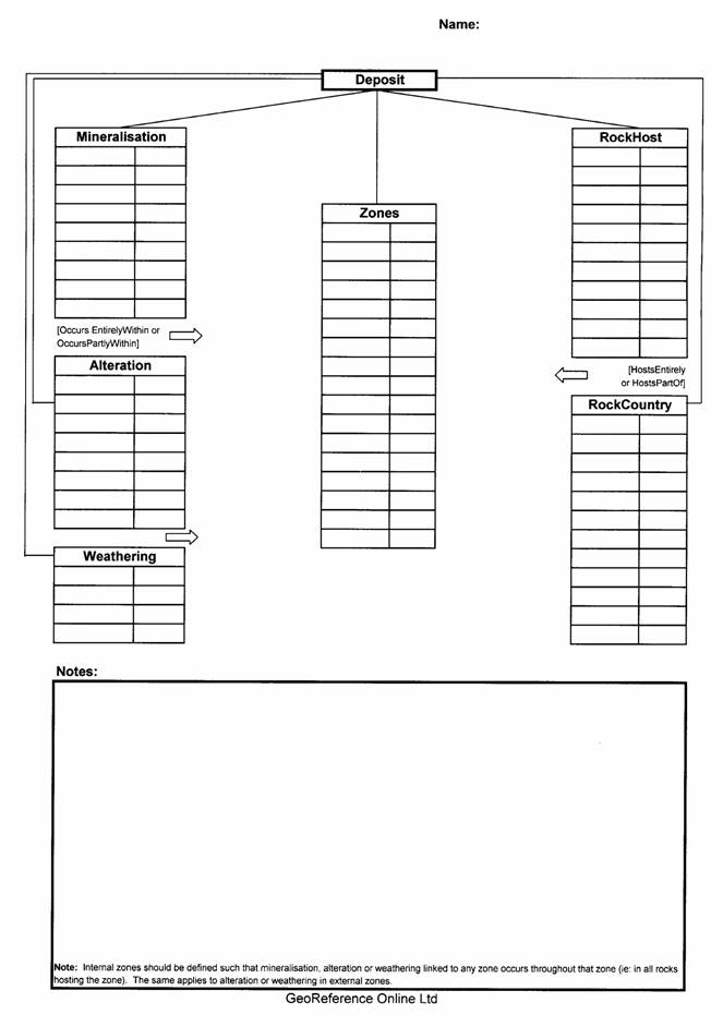
The GOL Mineral Deposit System Worksheet requires that, prior to inputting the description of a deposit or model, the user identifies: (a) the number and characteristics of mineralisation, alteration and weathering assemblages evident in the deposit system; (b) the host rocks and country rocks within which they occur; and (c) the zones (internal or external) within which unique combinations of these assemblages and rocktypes occur.
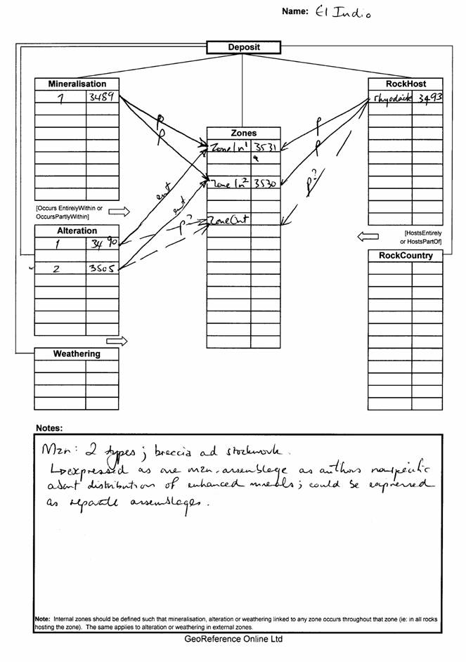
The worksheet, with its formally laid-out rows and columns, makes it easy to document, using hand-drawn arrow-connectors, which assemblages and rocktypes occur in which zones. (An example of a completed worksheet appears in Figure 3.) Once the worksheet has been manually completed, assemblages, zones and rocktypes should be entered into MineMatch. Finally, by reference to the worksheet, the links between assemblages and zones and zones and rocktypes may quickly be added. This is achieved for mineralisation/alteration/weathering by using one of the “OccursEntirelyWithin” or “OccursPartlyWithin” attributes. The attribute “OccursAtLeastPartlyWithin”, which is also available in the drop-down list, is usually appropriate only for model descriptions. In the example overleaf, the geologist has chosen to label “OccursEntirelyWithin” links with the word “ent”, and those which are “OccursPartlyWithin” with a “p”. For linking host rocks or country rocks to zones, use one of the “HostsEntirely” or “HostsPartOf” attributes. The right-side columns in each row-group have been used by the geologist to record the number given by the system to each assemblage, zone or rock. This is not a necessary step (particularly since these numbers change when the instance or model is exported or copied to another location) - but can make it easier to validate the work of another party. Conclusion
With the aid of a relatively simple worksheet, the sometimes complex relationships between the mineral assemblages, zones and rocktypes which characterise a mineral deposit may be laid out on paper ahead of entering these details into MineMatch. This exercise usually clarifies one’s thinking about a deposit, makes the data entry exercise easier to administer, and provides a useful record of work done. {Any comments or improvements on the above approach to mineral deposit characteristion would be gratefully received at georef@attcanada.ca or on the feedback pages of www.georeferenceonline.com } Georeference Online Ltd.
[2]
Or might have had the potential to reach ?!! (in the case of an uneconomic
mineral showing)
|