THE EFFECT OF STOCK EXCHANGE REPORTING STANDARDS ON THE COMMUNICATION AND INTERPRETATION OF GEOLOGICAL DATA IN MINERALS EXPLORATION, AND THE BROADER GEOLOGICAL COMMUNITY
Presentation to the
Prospectors and Developers Association of
March 2001
President
Georeference Online Ltd,
www.georeferenceonline.com
Introduction
New reporting standards for
listed Canadian exploration and mining companies, which are specified in
National Instrument 43-101, come at a time when there are a number of other
forces promoting standards in the minerals industry.
Prominent among these are
the need to manage large volumes of data from different sources, and the need
to share data more frequently than before, as made possible by the Internet.
Nevertheless, Instrument
43-101, with its obvious anti-fraud orientation, may still be seen as yet another
administrative chore that cuts into the exploration geologist’s quality
scientific time.
An alternative perspective,
however, and the subject of this presentation, is that 43-101 is a welcome
review of how exploration work should be recorded and reported, a review which
puts the spotlight on the words and concepts used in geology, and on how they
are extrapolated into the world of investment.
In this sense, 43-101 is complementary to all the other promoters of
standards in geology.
National Instrument 43-101
National Instrument 43-101
is a law which sets conditions under which public exploration and mining
companies are required to publish technical reports. The content of the reports and the
qualifications of their authors are specified by the Instrument. The purpose of the Instrument is to ensure
that securities commissions and investors are informed on technical matters
materially affecting the financial status of the listed companies. The Instrument may be viewed at the following
site: http://www.chamberofmines.bc.ca/toolkit/securities/csa_ni43-101start.htm
In essence, 43-101 requires
listed companies to provide technical audit trails which link their public
statements, their work plans and results, and geology as a whole, in a rational
way.
Computer databases are, in various roles, an increasingly important component of the audit trail required by 43-101.
The motivation for 43-101
was set out as follows:
“The CSA believe that
incremental costs of compliance with the proposed National Instrument will be
outweighed by the very significant benefits provided to investors, namely more reliable
and, with the use of standard terminology, more understandable and comparable
public information.”
While the focus of this
motivation was primarily on resource and reserve terminology, it is equally
relevant to exploration reporting. Minerals exploration is constantly adding
large volumes of data to the global geological data banks. Improved standards
of reporting this data will therefore provide significant benefits to
geological science in general.
The level of detail required
by Instrument 43-101 in exploration reports is significant, as shown in Form
F1, which is part of the Instrument.
Of particular relevance to
this paper are the following sections of Form F1, which appear together with
their requirements, as specified in the Instrument:
Section 9: Geological
Setting - Include a description
of the regional, local and property geology.
Section 10: Deposit Types - Describe the mineral deposit type(s) being
investigated or being explored for and the geological model or concepts
being applied in the investigation and on the basis of which the
exploration program is planned.
Section 11: Mineralization - Describe the mineralized zones encountered on
the property, the surrounding rock types and relevant geological controls,
detailing length, width, depth and continuity, together with a description
of the type, character and distribution of the mineralization
It should be clear that material reported under these headings, by a “Qualified Person” interested in preserving his or her reputation, is likely to be of value in the broader geological context, particularly if using terminology of a recognized standard.
Standards
Historically, standards have
proven difficult and slow to implement.
They are usually even more difficult
to fund, not least because they often constitute moving targets as different
interest groups make their perspectives known.
Further, standardization requirements in the computer era often have to
progress from defining terminology (eg: time periods or rock-types) to
considering grammars and ontologies [1].
(“Komatiites occur in the Archaean” is a grammatically and ontologically
acceptable statement, while “The Archaean occurs in komatiites” is
grammatically, but not ontologically, correct.)
This is not a new situation,
although the communication made possible by the Internet has made it a more
pressing one.
One attempt to address the
problem, as it pertains to rock nomenclature, was “Classification of Rocks”
published in 1955 by the Colorado School of Mines [2]. The preface
to this classification system, which is still adhered to by the US Forestry
Service, and some geologists in
“Geologists owe it to themselves and to workers in other sciences to use standard nomenclature”.
Geological standards are now, however, beginning to emerge in different forms. Some of them are different because they are mindful of the fact that they are going to be applied, not only in scientific discussion, but also within digital databases. This can sometimes upset the purists, but has rewards which must be taken into account during the often endless arguments about the best semantics to use. In today’s environment, any well-defined nomenclature is better than a void left by disagreement. The British Geological Survey Rock Classification System is a good example of a new, broadly based standard, which is sensitive to the requirements of digital systems [3].
Published late in 1999, this is a comprehensive new rock classification system which draws on the best of all previous rock classification schemes, and gives them expression in a way that makes them easier to use within digital databases. The system recognises four categories of rocks: igneous, sedimentary, metamorphic and surficial cover. It is documented in detail, and the documentation is freely downloadable on the Internet from http://www.bgs.ac.uk/bgsrcs/
Figure 1 shows a visual representation of part of the BGS system.
The system’s thorough documentation and its accessibility on the World Wide Web are both crucial characteristics for any nomenclature system that a Qualified Person may wish to refer to as being the standard adhered to when fulfilling 43-101 obligations.
It is also very easy to navigate - an important “usability” consideration. With a few mouse clicks it is possible to rapidly traverse the entire system, which includes more than 1200 rock names.
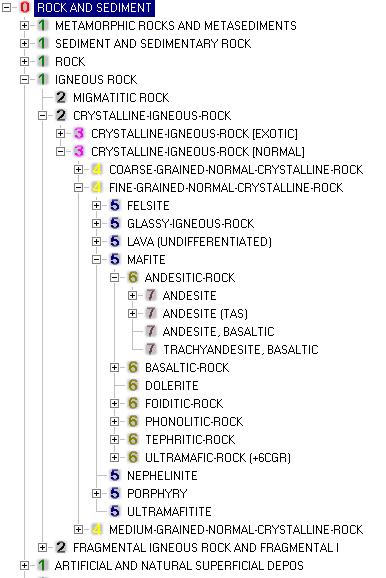
FIGURE 1: Extract from the British Geological Survey Rock Classification System
The system’s hierarchical design assists with understanding and navigation, but also, very importantly in the GIS field, makes legend matching and map-generalisation much more manageable tasks.
In contrast to the above standard, some new standards are very different from anything that most geologists encounter on paper, but are in fact paper representations of the implicit standards that geologists apply in their everyday work. These are standards of geological grammar and ontology. They are commonly represented using Entity-Relationship diagrams, and Universal Modeling Language diagrams - tools without which it is well-nigh impossible to design geological standards which measure up to the demands of the Internet age. The North American Data Model (NADM) is one of these [4].
The North American Data Model is a joint US/Canadian initiative originally aimed at establishing a standard information model for geological maps, but now including in its scope broader geoscience data modeling issues. Figure 2 shows one small part of the NADM Entity-Relationship model, and illustrates that the modeling necessary to reach the right ontologies is not simple, particularly when due consideration is given to the broad range of end-users of geological data.
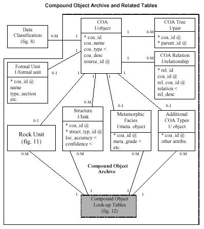
FIGURE 2: Extract from the Entity Relationship diagram of the North American Data Model.
Significant progress in standardization can, however, be made while the right ontologies are being hammered out. In the middle 80’s the USGS published their well-known catalogue of mineral deposit types of the world - a list of around 100 of the “highest-level” recognisable mineral deposit types [5]. Each deposit type was characterized using standard vocabulary in the different domains of geological time, associated elements, mineralisation form, host rock, associated minerals, and various other domains.
Figure 3 shows a representation of part of their classification, which, again, is hierarchical, easy to navigate, and rewarding to use provided that the user is familiar with the vocabulary used by the USGS compilation. It does not pay much explicit attention to ontology. By careful attention to nomenclature, a universally useful database has, nevertheless, been produced.
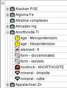
FIGURE 3: Hierarchical representation of data describing mineralisation models.
In this context, mention should be made of the FGDC standards for geological mapping which have been in development for a number of years, and which are due for release in mid-2001 [6]. These specifically address only the symbology used on geological maps (such as patterns for rock types and colours for geological time periods). However, since they were drawn up with considerable input from the North American geological community, and since maps are such an important component of communication in geology, they should be taken into account when developing standards for other parts of the world.
Finally, some standards are different in the way that they are delivered - in that they are delivered as lookup tables on the Internet for direct inclusion into new databases.
Arguably,
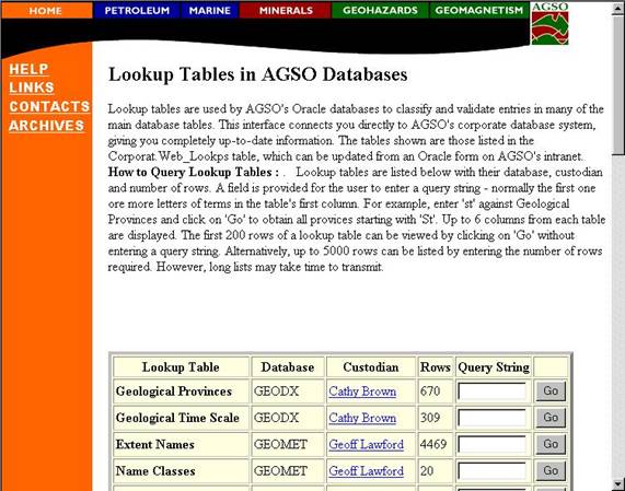
FIGURE 4: Australian Geological Survey Organisation Lookup Tables World Wide Web page.
Crucial to the successful application of such look-up tables, is the fact that each has a custodian. At the click of a mouse, users may make contact with the custodian. While AGSO may admit that their lookup tables are not yet perfect - this kind of arrangement ensures that they will rapidly evolve to cater for most of their users’ requirements. To ensure that they are used, the lookup tables are downloadable.
It is clear that many of these tables could play an
important role in assisting professionals to comply with standards way beyond
the shores of
The AGSO example provides a
view of standards activity at national level.
Standards do, however, also play an important role at the state level in
“Release of these guidelines marks the commencement of formal requirements for digital data reporting in SA. The Department now requires one hard copy and one digital copy of the technical report until further notice.”
They further state:
“The following standard data formats have been developed by a working group comprising representatives from all States and the Territory and in conjunction with industry. These standards which are being adopted Australia wide will provide uniformity in digital data reporting throughout Australia and will improve the efficiency of collection, storage and thus availability of data for future explorers.”
Many lookup tables similar to those of AGSO exist in Canada. The British Columbia Geological Survey’s MINFILE system is an example ( http://www.em.gov.bc.ca/mining/geolsurv/minfile/ ). It is also freely available, but in a somewhat less accessible form than the Australian system described above. It is a DOS-based system which has to be downloaded in its entirety. But once inside it, the user finds a number of useful lookup tables, each with a wordlist which can be exported, and which could, in turn, be used to standardize reports prepared under 43-101. The extent to which these wordlists are under the explicit care of a “custodian” is not clear to the outside user.
In regard to statutory exploration reporting in BC at present, provincial geologists translate the partly standardised reports they receive from exploration companies and prospectors into the standardised vocabularies within the MINFILE system. How much better might it not be to make the standards more easily accessible to those who have to prepare reports, and encourage them to do the standardising, as in the Australian model?
One good platform from which to encourage the use of such standards would be in the “Exploration Best Practice Guidelines” recently published by the Canadian Institute of Mining, Metallurgy and Petroleum in support of 43-101 ( http://www.cim.org/definitions/cimdef1.pdf ). These guidelines could endorse standard vocabularies such as those found in MINFILE, which could be made available though such initiatives as the Canadian Geoscience Knowledge Network ( http://cgkn.net ). As in the case of the Australian standards, it is clear that they would have international relevance.
Benefits of Standards
There is almost always a significant resistance to the adoption of new standards, which can be overcome only by delivering advantages to those who adopt the standards. Three advantages of standardization of geological terminology are presented below:
Concurrent overlay of data from different sources
More
sophisticated data analysis tools
More accurate, probably more complex, models of mineralisation
Each in its own way is a promoter
of standards.
Concurrent overlaying of data from different sources, as
implemented with XML, is the goal of a current CSIRO project in
As a second example, in the
data analysis field, there is a need for tools that can automate certain of the
steps in geological data analysis which currently require a geologist, and are
consequently never undertaken because they take too long.
Complete interpretation of
multi-element geochemical borehole profiles provides a good example. To automate anomaly recognition, “expected”
compositions of lithological units are required to allow software to
distinguish “noise” from significant signals such as anomalies.
Standardisation of rock
nomenclature allows the compilation of such “expected” values, along with many
other useful characteristics, which can then be used to implement advanced data
analysis techniques such as anomaly recognition - provided, of course, that the boreholes to be
interpreted have also been logged using the same standards of nomenclature.
A final, longer term, stock
exchange-relevant example of how adherence to standards makes possible better
geology, may be found in the representation of mineralisation models on the
computer. It was earlier shown that much
can be achieved by the judicious use of simple but comprehensive look-up tables
arranged in an hierarchical manner.
The same hierarchical
semantics can be used to describe individual mines. Once completed for many mines using a
consistent vocabulary, this representation of geological knowledge provides a
powerful environment for exploring the relationships between mineralisation
model sub-types, and their expected size or grade distribution.
A simple illustration uses
location as a distinguishing criterion for sub-type. In Figure 5, the size distribution curve on
the right was published for copper porphyry deposits by the USGS in 1986
[5]. The curve on the left was published
in 1993, also by the USGS, for porphyry copper deposits from Alaska and British
Columbia, showing a significantly smaller size expectation for Alaska and BC
porphyries [7].
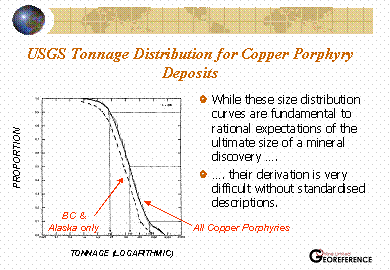
FIGURE 5: Size distribution curves for global copper
porphyry deposits and for copper porphyry deposits from British Columbia and
Alaska only.
Consequently, with the
passing of time, broader adoption of standard descriptive terminology can be
expected to lead to more accurate distinctions between mineralisation models
and their sub-types, and, consequently, more meaningful size and grade
distribution curves.
Conclusion
In summary, it is clear that
there are two perspectives to Instrument 43-101. The first is that, in calling for
standards-compliant descriptions of prospects, projects and mines, it should
result in better mineralisation–type categorization, and more realistic size
and grade expectations which, together with mining economics, fiscal regime,
political risk and other factors, can lead to more reliable estimates of the
values of the properties being evaluated.
The second is that these
standards can be expected to lead to better geology allround.
References:
[1] B. Brodaric and M. Gahegan "Geoscience Map Data Models, Open Systems GIS and Semantics," GeoCanada 2000, 2000.
[2] R. B. Travis "Classification of Rocks," Quarterly of the Colorado School of Mines, Vol 50, No 1, 1955.
[3] M. R. Gillespie and M. T. Styles "BGS Rock Classification Scheme. Volume 1. Classification of Igneous Rocks," British Geological Survey Report 1999.
[4] B.R. Johnson, B. Brodaric, G.L. Raines, J.T. Hastings and R. Wahl "Digital Geologic Map Model Version 4.3," US Geological Survey Report 1999.
[5] D.P. Cox and D.A. Singer "Mineral Deposit Models," US Geological Survey Report 1986.
[6] Geologic Data Subcommittee of the Federal Geographic Data Committee "Public Review Draft - Digital Cartographic Standard for Geologic Map Symbolization," US Geological Survey Report 2000.
[7] W.D. Menzie and D.A. Singer "Grade and Tonnage Model of Porphyry Cu Deposits in British Columbia, Canada, and Alaska, U.S.A.," US Geological Survey Open File Report 1993.