The British Geological Survey Rock Classification
System
In
1999 the British Geological Survey published the world's first strictly
hierarchical
Rock Classification System. It was specifically designed to aid in
computer mapping applications.
Unfortunately, until the release of
LegendBurster, there were no GIS systems which could capitalise on
this important development.
The LegendBurster system,
however, changes this situation forever, making it easy to incorporate the
BGS Rock Classification System, or any other hierarchical classification
system, into the analysis of geological data, and the production of
geological maps.
LegendBurster's tools for
re-attributing maps make it easy to translate any map's original rock-type
attributes into the BGS system - provided that the map's
original terminology is properly documented. The BGS RCS may be
downloaded in a format ready for import into LegendBurster from
Georeference Online Ltd's
TreeList Editor web pages.
Even when original terminologies are
not well documented, easy access to high level terms in the BGS RCS makes it
an ideal framework within which to generalise, and within which to manage
the problems of integrating many maps into one map, or the work of many
mappers onto one map.
Since LegendBurster is built around
the universally recognised ESRI shapefile, almost
any GIS data set is within its reach. Since LegendBurster does
not require an ArcView licence, it is a cost-effective solution to users of
GIS systems other than ArcView.
Related Info
.
|
Using Hierarchical Structure to add Value to Maps
Hierarchically-structured attributes are difficult to
manage in the relational database environment of most GIS systems.
For queries to be possible at different levels in a
hierarchy, an additional field has to be added to the map's attribute table
for each possible level in the hierarchy. Populating and
maintaining all these fields is time consuming, expensive, and usually
fraught with errors.
The semantic net structures used in LegendBurster
lend themselves to efficient implementation of hierarchical relationships.
The Geology of Cornwall
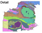
Click
here to examine the
individual polygons of this map
[0.7Mb image - High Speed Best]
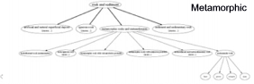
As an example, both of the maps shown above were
derived from the same single attribute. The "Detail" map resulted from
a conventional "unique values" shading, in ArcView, of the map on rock-type.
The "Overview" map was produced in ArcView by combining the results of three
single-value LegendBurster queries (rock-type = "igneous", then
"metamorphic", and then "sedimentary"). In each case, the LegendBurster
system was able to consolidate all igneous, metamorphic or sedimentary rocks
into the query result by referencing the hierarchy to determine what class
each "detailed" rock-type belonged to.
While it is important to capture as much detail as
possible on most maps, very often the most valuable renditions of that
detail are at a more general level. LegendBurster, together
with with the BGS Rock Classification System, provides this essential
mapping capability to geologists working with bedrock and surficial geology.
|